

Verify or Burn a Claim: Chaining Photo, Map, and Public Records
this is the capstone. one technique rarely proves anything, but chained together they are brutal. the job: someone claims “this photo was taken at our hq on july 14, 2026.” your job is to decide if that is true, using nothing but the image, public maps, the sun, and the record. spoiler: most false claims die on the timestamp before you ever get to the geometry.
the method: treat the claim as a hypothesis
write the claim as testable facts: a place (hq), a date (july 14), and implied conditions (daylight, that building, that season). then try to break each one. a claim only survives if every independent check agrees. you are not trying to confirm it, you are trying to falsify it, and if you cannot, it stands.
link 1: the metadata sanity check
exif first, as always. not for gps you will probably not get, but for the timestamp. a create date that predates the claimed date is a contradiction you can stop on.
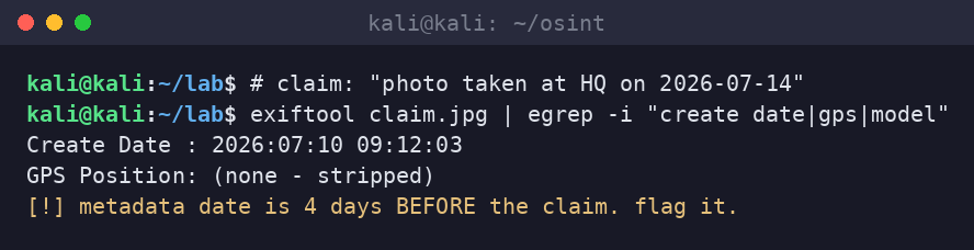
also check software tags (was it edited or screenshotted?), and whether the file is an original or a re-save. a claim’s “live photo” that is actually a screenshot of a screenshot is already in trouble.
link 2: the map, the satellite, the sun
now test place and conditions together. reverse-geocode the claimed coordinates. compare the scene to dated satellite and street-level imagery: does the building, the crane, the parking lot, the tree line match the claimed date? construction is a gift here, because cranes and scaffolding are time-stamped by imagery providers. then run the sun check: at the claimed place, date, and time, the sun has a specific azimuth and elevation, so shadows must fall a specific way. if the photo’s shadows disagree, the claim disagrees with physics.
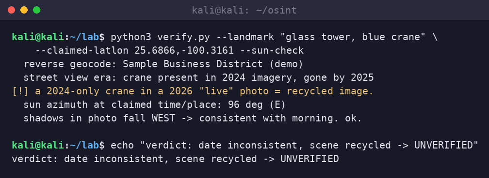
this is where claims usually collapse: the scene is real but from the wrong year (recycled image), or the shadows are physically impossible for the stated time, or the “landmark” is in a different city entirely. each check is independent, which is what makes the combination so hard to fake.
link 3: the public record
corroborate against things that were written down by someone else: weather records for that date and place (was it really sunny?), news or event records, business filings, permit and construction records, flight or vessel tracking history if relevant. public records are the witnesses who have no stake in the claim. if the claim says a clear afternoon and the weather archive says storms all day, you are done.
the verdict
- metadata: does the timestamp support the date, or contradict it?
- imagery: does the dated satellite/street view match the claimed scene and year?
- sun and shadows: are they physically consistent with the claimed place, date, time?
- public record: do weather, events, and filings agree?
- verdict: verified, unverified, or inconclusive, with the evidence for each link shown
and say “inconclusive” when it is inconclusive. the discipline is admitting what you cannot prove, not forcing a verdict to feel clever.
what defenders and investigators can do
- fraud: chain these to debunk fake proof-of-loss photos, staged “evidence,” and recycled images in insurance, romance, and refund scams.
- journalism: publish the method alongside the verdict so the finding is reproducible, not a vibe.
- detection teams: the same rigor applies to validating threat-intel claims and “we saw this ioc here on this date” assertions.
- everyone: understand that your own posts are this verifiable, and post accordingly.
sloth take
no single clue is proof, but four independent clues that all agree are very hard to argue with, and four that disagree kill a claim stone dead. exif for the date, satellite for the scene, the sun for the physics, the public record for the witnesses. most lies fall apart on the timestamp. chain the checks, show the work, and say “inconclusive” when you mean it.
sources
- Bellingcat guides to geolocation, chronolocation, and verification methodology
- SANS OSINT Summit material on image and claim verification
- ExifTool; SunCalc and NOAA solar position references; public satellite and street-level imagery archives
- Public weather, event, and corporate records as independent corroboration
- Lab artifacts generated on-box 2026-10-17 (synthetic claim and terminal captures)